
-
Previous
Centimeter Level Augmentation Service (CLAS)

-
Next
Satellite Report for Disaster and Crisis Management (DC Report)

Multi-GNSS Advanced Orbit and Clock Augmentation - Precise Point Positioning (MADOCA-PPP)
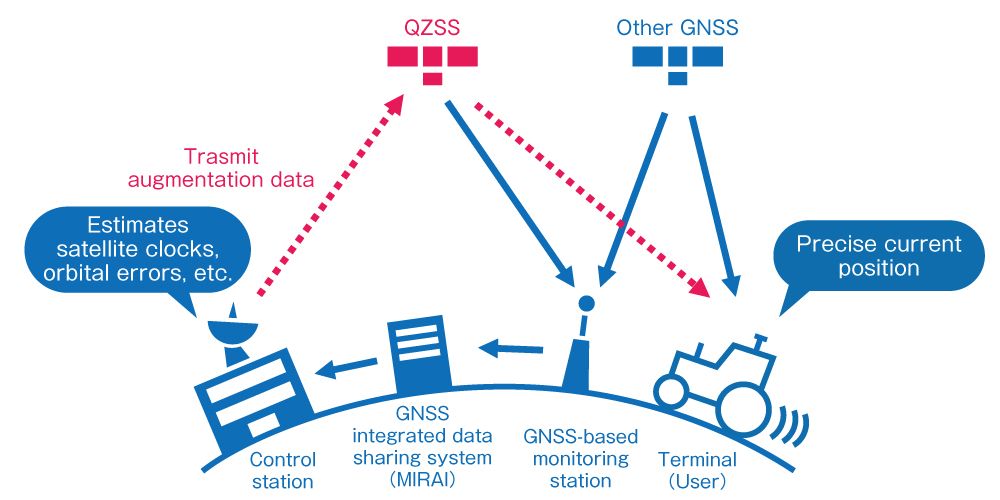
To provide highly precise positioning augmentation services that can be used in Asia-Oceania Region, errors caused by positioning satellites are computed using observation data from domestic and overseas GNSS monitoring station networks such as IGS and MIRAI, and obtained correction data is transmitted from QZSS as L6 signal. Users can use high-precision positioning using PPP method by using a GNSS receiver that supports the L6 signal of QZSS.
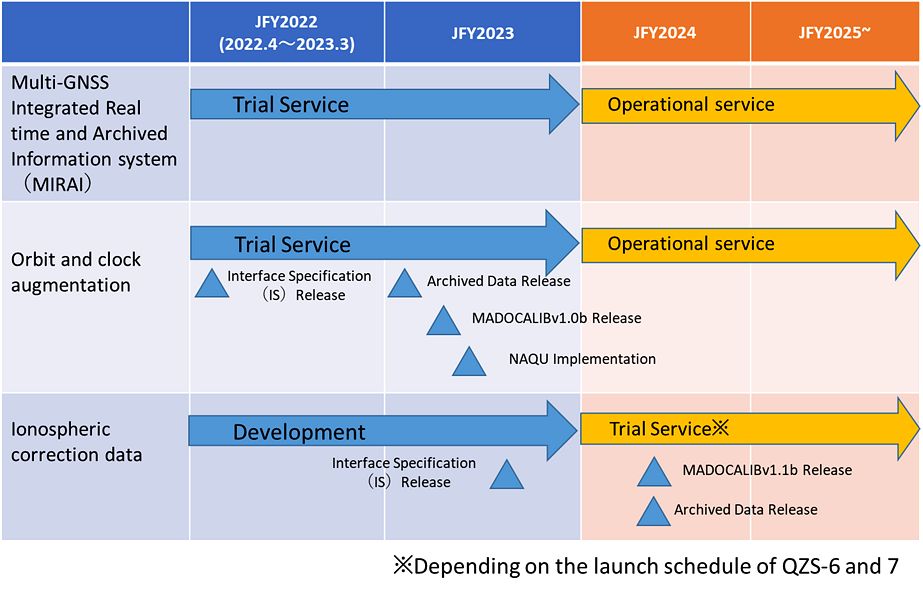
Since the augmentation data can be used not only in Japan, but also in Asia-Oceania region, it is expected to be used in various applications including the maritime field. Trial service (*1) begun on September 30, 2022, and operational service (*2) started on April 1, 2024.
*1 trial service: Operation for development and validation with the same quality as operational service.
*2 operational service: Official operation as a service of QZSS with development and validation completed.
In addition to positioning for various fields of demonstration, such as automated driving, IT construction, and IT agriculture, this service can be used to estimate the amount of water vapor in the atmosphere, and is expected to be effective in improving the accuracy of weather forecasts. The highly accurate clock error information contained in the augmentation data is expected to be used in fields where precise time synchronization is required.
The PPP method used in this service requires 20 to 30 minutes of pre-observation to obtain highly accurate position. To shorten this pre-observation time, QZSS also plans to transmit wide-area ionospheric correction data on L6 signal (scheduled to begin trial service after QZS 6-7 will be launched).
[Multi-GNSS Integrated Real time and Archived Information system (MIRAI)]
To generate augmentation data of MADOCA-PPP, real-time data observed in a network of GNSS monitoring stations in Japan and abroad is needed. This real-time data is collected by the GNSS Integrated Data Sharing System (named MIRAI, Multi-GNSS Integrated Real time and Archived Information system) with cooperation from domestic and overseas organizations and universities in providing monitoring station data.
This real-time data collected by MIRAI is not only used to generate augmentation data for MADOCA-PPP, but is also intended to be widely used for research and development related to GNSS around the world. The data is available free of charge on the Internet.
Users (registration required) can check the status of monitoring stations connected to MIRAI on the Web, receive real-time data (RTCM 3 format) from monitoring stations, and download archived data (RINEX format). Archived data is available free of charge at the following website.
We welcome cooperation in providing monitoring station data. Please contact us through the following website.

-

Overview of the Quasi-Zenith Satellite System (QZSS)
-

What is the Quasi-Zenith Satellite System (QZSS)?
-
QZSS is Becoming a Seven-satellite Constellation
-

Advantages of QZSS
-

Service Comparison
-

Transmission Signals
-

Satellite Positioning, Navigation and Timing Service (PNT)
-
Sub-meter Level Augmentation Service (SLAS)
-
Centimeter Level Augmentation Service (CLAS)
-
Satellite Report for Disaster and Crisis Management (DC Report)
-

QZSS Safety Confirmation Service (Q-ANPI)
-

Positioning Technology Verification Service
-

Signal Authentication Service
-

Public Regulated Service
-

SBAS Transmission Service