-
Previous
Satellite Report for Disaster and Crisis Management (DC Report)

-
Next
Positioning Technology Verification Service

QZSS Safety Confirmation Service (Q-ANPI)
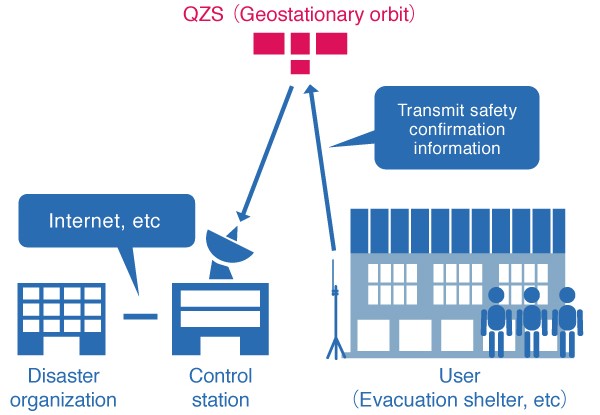
Discussions are underway for using the QZSS Safety Confirmation Service (Q-ANPI) to transmit evacuation shelter information to control stations and collect information via Quasi-Zenith Satellites (QZS) during times of disaster. Among the QZS, Q-ANPI can be used with satellites stationed on geostationary orbits (GEO). This service is available on S-band devices that support Q-ANPI. Please note that this service can only be used in Japan and its coastal areas.

During disasters, this service will send notices via satellites about the location and opening of evacuation shelters, number of evacuees, and circumstances at evacuation shelters. This information is essential for rescue operations, including comprehending the circumstances of the disaster and people who are isolated. Usage methods are also being considered to allow close relatives to search for individuals.
-

Overview of the Quasi-Zenith Satellite System (QZSS)
-

What is the Quasi-Zenith Satellite System (QZSS)?
-

QZSS is Becoming a Seven-satellite Constellation
-

Advantages of QZSS
-

Service Comparison
-

Transmission Signals
-

Satellite Positioning, Navigation and Timing Service (PNT)
-

Sub-meter Level Augmentation Service (SLAS)
-

Centimeter Level Augmentation Service (CLAS)
-

Multi-GNSS Advanced Orbit and Clock Augmentation - Precise Point Positioning (MADOCA-PPP)
-

Satellite Report for Disaster and Crisis Management (DC Report)
-

Positioning Technology Verification Service
-

Signal Authentication Service
-

Public Regulated Service
-

SBAS Transmission Service


