Satellite Positioning, Navigation and Timing Service (PNT)
Satellite positioning, navigation and timing service to complement GPS
By sending signals from Quasi-Zenith Satellites (QZS) of the same frequency and same timing as GPS, this service can be used in an integrated way with GPS for highly precise positioning.
At present, there are two types of positioning errors caused by satellite positioning: 1) errors caused by the small number of satellites and 2) ionospheric errors. Using QZS improves two factors, the errors become much smaller.
1) Errors caused by the small number of satellites
(a) Multipath errors
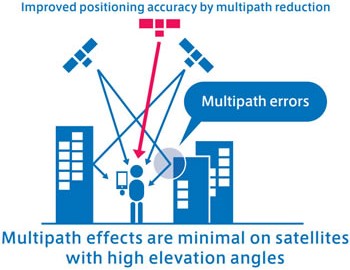
“Multipath” means that satellite signals do not just arrive in a straight line; they are transmitted in multiple routes while being reflected off mountains, buildings, etc. It takes time for the reflected signals to arrive at their destination. This results in a more distant calculation, and is a factor that negatively impacts accurate satellite positioning.
For satellite signals transmitted by positioning satellites with high elevation angles, multipath effects do not occur easily because the reflected waves do not arrive at distant locations. Accordingly, overall positioning errors can be reduced. With a large number of satellites used for positioning, satellites with high elevation angles are included, which can improve positioning errors.
(b) Satellite constellation errors
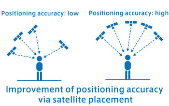
For satellite positioning, accuracy improves when satellites are distributed evenly in a wide range in the high-altitude sky. The degree to which the satellites are arranged in the sky in a balanced manner is called “Dilution of Precision” (DOP). For horizontal positions, it is known that DOP improves when satellites with low elevation angles are included.
(c) Countermeasures to increase the number of satellites
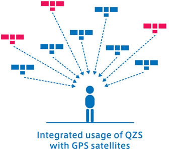
To improve positioning errors as described in (a) and (b), more visible satellites are ideal. However, GPS are shared throughout the world, so the number of satellites is not sufficient at each location.
QZS transmit the same positioning signals as GPS (L1C/A, L2C, and L5) and have clocks that are synchronized with GPS, so they can be used as if they were additional GPS satellites.
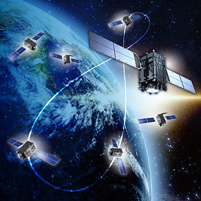
QZS spend roughly 16 hours at elevation angles of 20° or greater from the area near Japan. With a four-satellite constellation, more satellites will be visible in combination with GPS, which will resolve multipath and satellite placement errors. This will also improve positioning stability even in mountainous and urban areas, where there are narrower fields of vision due to buildings, trees, etc.
2) Ionospheric errors
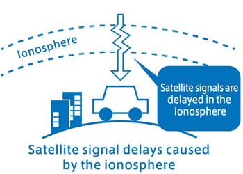
Signal delays caused by the ionosphere are the most common type of positioning error. The ionosphere is a region of the upper atmosphere from 100 to 1,000 kilometers that is charged with electricity. When satellite signals from satellites pass through the ionosphere, their speed decreases. Because the arrival of the satellite signals is delayed, an error results when the distance between the satellite and user is calculated as longer than it actually is.
(a) Improving ionospheric errors with multi-frequency signals
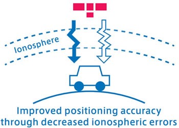
Satellite signal speed delays caused by the ionosphere differ according to the frequency of the satellite signals. Due to this characteristic, errors caused by delays in the ionosphere can be estimated and mostly resolved by simultaneously transmitting satellite signals of multiple frequencies from one satellite. Therefore, errors can be improved by using satellites that can transmit signals with multiple frequencies.
In the case of GPS satellites and QZS, L2C or L5 signals can be used in combination with L1C/A signals to improve ionospheric errors.
(b) Improving ionospheric errors with single-frequency signals
Dual-frequency receivers are very expensive, so it is expected that single-frequency receivers will also be used widely for the immediate future.
The Klobuchar model parameter, which transmits standard L1C/A positioning signals, is a way to achieve ionospheric correction for single-frequency receivers.
The Klobuchar model uses a formula to approximate the circumstances in the ionosphere. Users can perform ionospheric errors correction by transmitting positioning signals while combining the parameter values of this formula with orbital information, etc. In addition to QZS, parameter values calculated by the United States government are also transmitted by GPS satellites.
A single formula is used to approximate the entire earth with GPS. In contrast, QZSS produces and transmits two types of parameters: parameters for the Southeast Asia and Oceania regions, and parameters for the area near Japan. Because this is an approximation formula, it is expected that accuracy will be improved as the target regions are made smaller, and that it will be possible to achieve precision of two to three meters in the area near Japan (except in cases of ionospheric disturbance).
-

Overview of the Quasi-Zenith Satellite System (QZSS)
-

What is the Quasi-Zenith Satellite System (QZSS)?
-
QZSS is Becoming a Seven-satellite Constellation
-

Advantages of QZSS
-

Service Comparison
-

Transmission Signals
-
Sub-meter Level Augmentation Service (SLAS)
-
Centimeter Level Augmentation Service (CLAS)
-

Multi-GNSS Advanced Orbit and Clock Augmentation - Precise Point Positioning (MADOCA-PPP)
-

Satellite Report for Disaster and Crisis Management (DC Report)
-

QZSS Safety Confirmation Service (Q-ANPI)
-

Positioning Technology Verification Service
-

Signal Authentication Service
-

Public Regulated Service
-

SBAS Transmission Service


