
User Guide (Construction and Agriculture)
Highly precise positioning achieves more efficient work
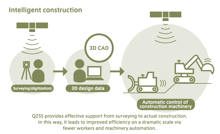
More efficient survey work
Augmentation information produced by GNSS-based control stations is sent via the QZSS (Michibiki) Centimeter Level Augmentation Service (CLAS) service, so surveying using these control stations can take place at any time. In this way, for instance, it is possible to survey points of reference even in mountainous regions where mobile phone service is not available. This results in more effective survey work. Moreover, three-dimensional maps of construction areas can be created by high-precision surveying, allowing construction to be started without delay.
Intelligent construction greatly changes public work processes
The QZSS (Michibiki) CLAS service can be used even where mobile phone service is not available, so construction machinery that is capable of receiving signals can be utilized at work sites. The trajectories of bulldozer blades can also be controlled down to the centimeter unit. Consequently, it is possible to carry out detailed construction work in line with drawings. Via the constant positioning that is performed during the work, one can confirm at any time whether the work is going according to plan.
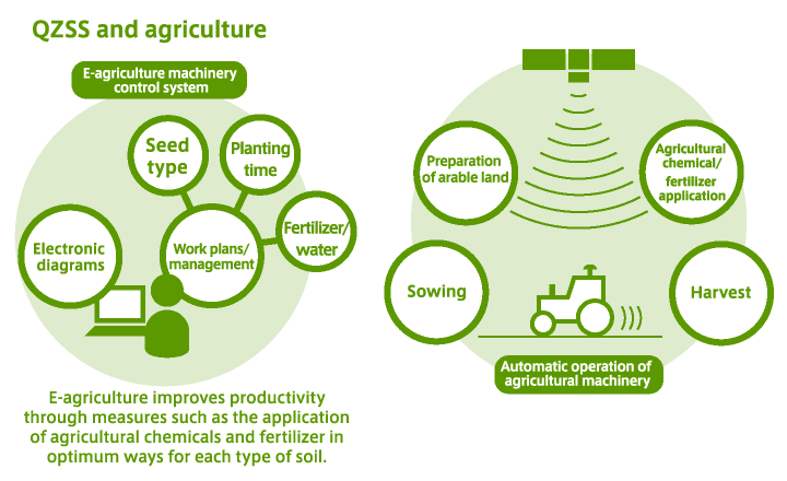
More systematic farming via e-agriculture
Small-scale farms are the norm in Japan and Southeast Asia; these farmers must rely on their memories for farmland management, including seed types, planting times, and fertilizer and water usage. In contrast, for large-scale farming in the United States and Australia, e-agriculture that utilizes GPS or other positioning satellites has come into widespread use to manage cultivation in each region.
In the future, it is predicted that collective farm management will grow in Japan and Southeast Asia, and farmland management using positioning satellites will be implemented. Due to complicated agriculture formats and geographical features, position information will need to be managed in a highly precise way. To that end, the QZSS (Michibiki) satellite positioning service helps develop an environment for high-precision e-agriculture.
In addition, efficient agriculture is required because of the decreasing number of farmers. The QZSS (Michibiki) CLAS service will make it possible to automatically operate agricultural machinery, allowing small numbers of people to manage large-scale farms.