User Guide (Automobiles [Logistics and Passenger Transport])
Highly precise positioning innovates passenger transport and logistics
A bus location service that reduces travel stress
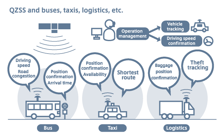
It is possible to accurately understand bus locations with high-precision positioning that utilizes QZSS (Michibiki), so precise data on driving speeds and traffic delays is also accumulated. Based on such data, it will be possible to accurately display at bus stops the time required before the next bus arrives, which helps in the creation of accurate operation plans.
Enhanced security through package tracking

For items that must be kept very secure—such as important documents or expensive items sent via home delivery services—location tracking is possible via GPS tags. However, with GPS satellites only, the number of satellites is insufficient and position information cannot be obtained in some cases, so complete tracking cannot be accomplished at all times.
QZSS (Michibiki) will make it possible to understand detailed information about item positions. This will result in simpler tracking, and also make it easier to find items if any trouble occurs.
Peace of mind during long-distance travel by bus or truck
QZSS (Michibiki) can be utilized for operation management and tracking for vehicles that travel long distances, such as long-route buses and trucks. GPS satellites have been used in the past to confirm vehicle position information, but high-precision positioning via QZSS (Michibiki) helps prevent accidents as well by monitoring, from position information, when bus or truck operation has become unstable as a result of the drivers' problems.
Operation management and the dispatch of taxis via high-precision positioning
When using car navigation systems in urban areas with high road density, there are many cases in which GPS satellites are obstructed due to buildings and other objects. At times, when using the map-matching method (a method to move positions on nearby roads), one can make a mistake and end up on a different road.
The QZSS (Michibiki) satellite positioning service accomplishes highly precise positioning even in urban areas, which makes it possible to accurately understand taxi positions and allows effective taxi dispatch. For instance, when a user calls for a taxi, they can send accurate directions—including the shortest route—to the taxi at the closest position, which leads to improved convenience.


