-
Previous
5th EU-Japan Public and Private GNSS Roundtable 2021
-
Next
[Report] Deliberations on QZSS at the 7th Session of the IMO's NCSR
RPD Challenge 2020, a QZSS hackathon organized by the Cabinet Office, MGA, and GISTDA
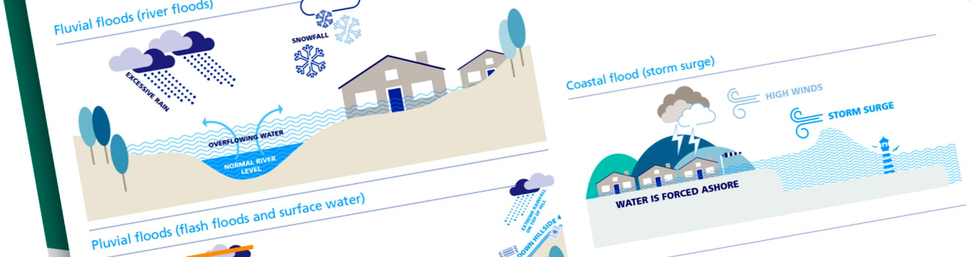
Together with the Geo-Informatics and Space Technology Development Agency (GISTDA) and Multi-GNSS Asia (MGA), from July 8 to 9 the Cabinet Office held the Final Review for the Rapid Prototype Development Challenge 2020 Extended (RPD Challenge 2020) hackathon(*) for projects to develop natural disaster-related applications utilizing the Quasi-Zenith Satellite System (QZSS).
This hackathon drew approximately 100 students and engineers from across the world, who began working on their projects last October. Online lectures were delivered by experts, and the teams repeatedly held meetings, on the theme of "Solutions for Disaster Management: Tsunami/Flooding." Before the Final Review, teams deepened their understanding of QZSS and GNSS while investigating water disaster measures and developing applications and systems to resolve these issues. The projects by the four award-winning teams are introduced below.
(*) Hackathon: A portmanteau of "hack" and "marathon," this word refers to events in which participants code programs in a limited period of time.
A system for accurately understanding and transmitting flood information
-- Team CULFEWS (Grand Prize/MGA Award)
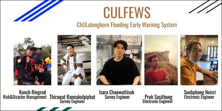
A team of human resources with expert knowledge in disaster management, surveying, electronic engineering, and other fields (provided by CULFEW)
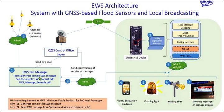
CULFEWS, a team with five members from Chulalongkorn University in Thailand, proposed an early warning system for floods. A problem in areas with frequent flooding is that early warning information is not trusted by citizens, which delays the speed of evacuation. To improve the credibility of warning information, Internet of Things (IoT) sensors (which are connected to a network to gather information) are utilized to obtain water level information and reliably predict flood scope while referring to past flood data. This project also uses the satellite Emergency Warning System (EWS) and other technologies to transmit information. To send warning information to the appropriate area, it utilizes broadcasting from a dense network of disaster prevention wireless towers, as well as digital signage.
Integrating GNSS/QZSS information with existing disaster prevention infrastructure (provided by CULFEW)
This team’s project was well rated for its high level of completion. They created a character called "FLOODBOY" as an app for LINE, which has many users in Thailand as well, incorporating a system in which FLOODBOY is used to gather inundation information from users and provide evacuation instructions. In addition, the project also includes camera image processing to measure water levels, government agencies to cooperate with for installing wireless disaster prevention towers, processes for handling information, and even a dashboard design for controlling the system.
Team member Mr. Purk Sasithong, who is majoring in electronic engineering, said, "No food or power was available during the 2010 flooding, which was a difficult experience. Some people suffer because they don’t know how to act due to a lack of information, which is something I hope we can help prevent."
Mr. Kunch Ringrod, who is studying risk and disaster management, analyzed the future challenges as follows: "Even when a flood is approaching, people tend to give more credence to what their neighbors say than the information reported in the news. If this system is to be trusted, we must be flexible and adapt to local circumstances."
Promptly providing safe evacuation routes
-- Team SWAN (Michibiki Award)
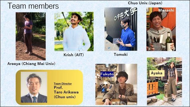
SWAN is a joint Thai/Japanese team (provided by SWAN)
SWAN consists of members from Chiang Mai University and the Asian Institute of Technology in Thailand, and from Chuo University in Japan. This team presented its project for an application that recommends safe evacuation routes. It refers to position information from GNSS (including QZSS) and EWS information to choose a scenario in accordance with the current circumstances from among multiple natural disaster scenarios created in advance. The user is immediately provided with a recommended safe evacuation route that takes into consideration the terrain, elevation, and other factors.
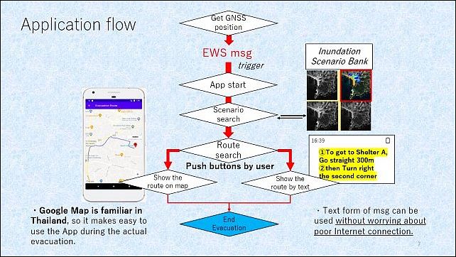
Application flowchart (provided by SWAN)
The team plans to link EWS messages, which notify users about natural disasters, with QZSS. The team did a trial run using Spresense, a board computer from Sony that can receive L1S signals, in which simulated data was received, decoded, and sent to a smartphone.
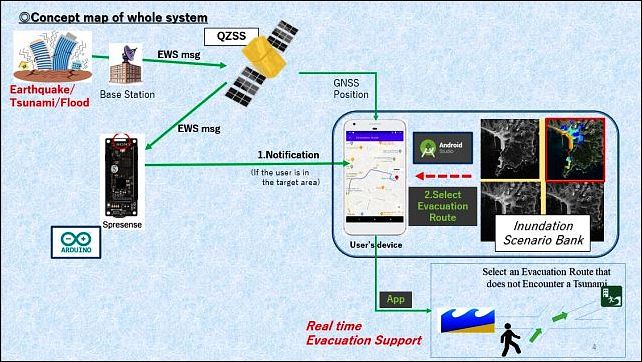
When natural disaster information is received from QZSS, the app sends a recommended evacuation route (provided by SWAN)
The key is the "Scenario Bank," the system by which an optimal route is quickly selected from the results of numerous simulations with different conditions. If the app finds a safe evacuation route for the scenario, it is recommended to the user. The team also described its future vision for more precise evacuation route recommendation using larger quantities of information collected from drones, surveillance cameras, etc.

Presenter Ms. Areeya Tivasuradej from Chiang Mai University
Chuo University Professor Taro Arikawa, the team director, explained the background to this project. He said, "This is an initiative to build 'soft' disaster prevention infrastructure without relying solely on hardware like breakwaters and seawalls. It is an attempt to combine the results of actual observation and measuring with simulation data, and to connect this to future urban visions linked with prediction and behavior support."
The members described the following results.
Ms. Tivasuradej said, "I majored in geography, and I was able to learn a lot about technology, which was my weak point. I was also greatly inspired by working together with people from another country. Participating in this hackathon was a new adventure for me. Our achievements as a team have made me want to develop them further."
"Learning about the unimaginable local circumstances in Thailand made it possible for us to come up with a more pragmatic project. This has also increased my motivation to do my research on tsunami disaster prevention," said Mr. Tomoki Shirai of Chuo University.
The team's name, "SWAN," was inspired by a foot-pedal swan boat (like those you see at parks) and expresses their desire to paddle together to a farther distance.
Flood prediction with dynamic beacons
-- Team SGNAVI (Michibiki Award)
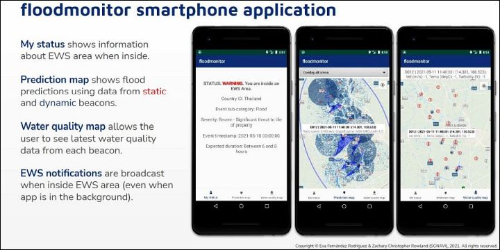
floodmonitor smartphone app (provided by SGNAVI)
The members of SGNAVI are Mr. Zachary Rawland, an aerospace engineer from the United Kingdom who lives in Leiden (Netherlands), and Ms. Eva F. Rodriguez, a communications engineer residing in Madrid (Spain). Their project includes two types of beacons, utilizing small sensors equipped with GNSS functionality in flood countermeasures.
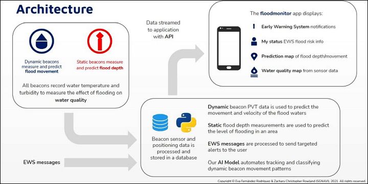
This system utilizes two types of beacons: dynamic and static (provided by SGNAVI)
Dynamic beacons released into rivers are equipped with the minimum level of functionality, including a GNSS receiving function, sensors (temperature, acceleration, water turbidity, etc.), and a communications function. The dynamic beacons are tracked as they move in water currents. To evaluate the credibility of this data, multiple neural network models were compared and verified.
Static beacons use ultrasonic sensors to obtain water depth data. Mathematical processing is performed on this data to predict the range of the flood, which will be provided via the app together with EWS notifications.

Mr. Zachary Rawland
Rawland has experience with a wild bird tracking system from another hackathon, which made him think of using small beacons for flood prediction. His evaluation of Spresense, the single-board computer, is, "Spresense is great because it supports programming languages such as C++ and Python, and it’s also a GNSS receiver."

Ms. Eva F. Rodriguez
Ms. Rodriguez described her expectations of GNSS technology as follows: "I was surprised that we can do positioning and receive messages at the same time on such a small receiver. I also think the QZSS concept is wonderful for this reason. EWS will be available in Europe from 2023, and preparations are underway to operate EWS in a common format with QZSS. This may be an opportunity to create warning systems that have never existed before."
Detecting tsunamis with low-cost GNSS buoys
-- Team BSU (GISTDA Award)

Mr. Pakpoom Tiwakornkit
Mr. Pakpoom Tiwakornkit from Bangkok Suvarnabhumi University won the GISTDA Award for his project for a tsunami EWS integrating five auxiliary services.

Auxiliary Tsunami Detector service (provided by BSU)
Existing GNSS tsunami buoys are extremely expensive. This project uses sea surface height data from low-cost GNSS buoys and performs Fast Fourier Transformation (FFT) processing. This removes the influence of short-period waves (caused by wind over the water's surface) to extract and detect long-period tsunamis.
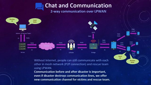
Chat-based communication system (provided by BSU)
Mr. Tiwakornkit presented a large-scale project is to improve and integrate existing machinery and systems to reduce the number of tsunami victims. It includes a chat system that mutually connects smartphones through technologies such as Bluetooth, Wi-Fi, and Low-Power Wide-Area Network (LPWAN) to send early warning information and EWS messages about tsunamis, even when telecommunications provider lines are unavailable. It also includes a system that detects people from surveillance camera images installed in cities to help find disaster victims and rescue workers, and uses smartphone position information to notify users of optimum evacuation routes.
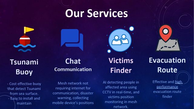
Auxiliary services include the Tsunami Detector, Victims Finder, etc. (provided by BSU)
Regarding this award and his future plans, Mr. Tiwakornkit said, "RPD Challenge 2020 was a precious opportunity, and I learned a great deal by talking with people such as Prof. Teruyuki Kato (University of Tokyo emeritus professor, the foremost authority on GNSS tsunami buoys). Right now I am taking leave from my university to care for my sick mother. I have not made any further progress on this project, but I want to get back to it once she feels better."
In-person seminars are being planned in Japan
The members of the four teams that won awards in RPD Challenge 2020 were given prize money as well as an extra prize: airplane tickets to Japan. In-person seminars, company and facility tours, and other events will be held to further enhance their plans.
(Interviews, text: Mitsunari Kita, science and technology writer)
Reference
- The Rapid Prototype Development (RPD) Challenge
- Multi-GNSS Asia (MGA)
- Multi-GNSS Asia (YouTube channel)
- [YouTube] MGA RPD Challenge 2020 Extended: Team CULFEWS
- [YouTube] MGA RPD Challenge 2020 Extended: Team SWAN
- [YouTube] MGA RPD Challenge 2020 Extended: Team SGNAVI
- [YouTube] MGA RPD Challenge 2020 Extended: Team BSU
-
Dec.15,2021
5th EU-Japan Public and Private GNSS Roundtable 2021
-
Mar.05,2020
[Report] Deliberations on QZSS at the 7th Session of the IMO's NCSR
-
 Apr.15,2019
4th EU-Japan Public and Private GNSS Roundtable Meeting by the Cabinet Office and the European Commission
-
 May.04,2017
EU-Japan GNSS Mission (Day 2)
-
 May.03,2017
Signing of a Cooperation Arrangement on Satellite Positioning Application
-
 May.02,2017
EU-Japan GNSS Mission (Day 1)
-

Information about events related to QZSS
-
 Sep.12,2017
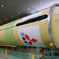
Mitsubishi Heavy Industries Exhibited the first and second stages of QZS-4 Launch Vehicle
-
 Aug.18,2017
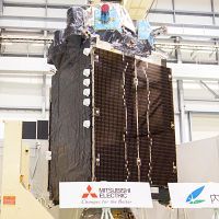
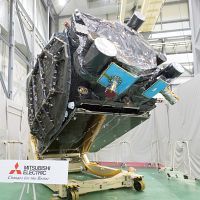
Exhibition of the QZS-4
-
 Aug.17,2017
Live Broadcast of the QZS-3 Launch
-
 Jul.07,2017
Mitsubishi Heavy Industries Exhibits the QZS-3 Launch Vehicle
-
 Jun.16,2017
Exhibition of the QZS-3
-
 Jun.01,2017
Successful Launch of QZS-2
-
 May.30,2017
Live Broadcast of the QZS-2 Launch
-
 Apr.25,2017
Mitsubishi Heavy Industries Exhibits the QZS-2 Launch Vehicle Core Frame
-
 Apr.07,2017
Exhibition of the QZS-2